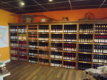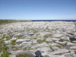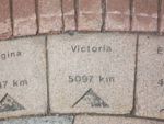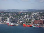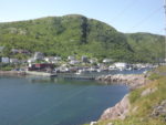
It seems both a very long time ago since we left Victoria and unbelievable that we have already spent over 2 weeks in Newfoundland. It has been most illuminating and we have covered more than 3000 km with only about 700 km along the TCH. Since the last posting we travelled up the Bonavista Peninsula, through Gander to Twillingate and the Baie Vert Peninsula which was interesting, but a lot of driving through relatively flat acres of lakes, scrubby trees and bush. The coastal villages had magnificent settings, but the houses were far apart to provide areas for drying the cod. The locals only met at kitchen parties and at church. In Twillingate we visited one of 2 fruit wineries in Newfoundland – the Auk Island Winery which produces about 15 different wines from an assortment of fruit, all picked locally. Most of them were well made, but they tended to have the sweetness of a social or dessert wine. We did buy a bottle of blackberry “port” which had been fortified with screech!
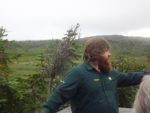
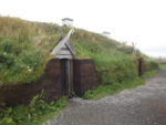
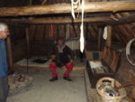
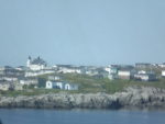
We’ve spent the last few days on the Northern Peninsula visiting what are, perhaps, Newfoundland’s two most famous sites. At the extreme north end of the Peninsula – and almost as far north as one can go in Newfoundland, there is a UNESCO World Heritage Site at L’Ance aux Meadows run by Parks Canada (PC) This is where it is thought the first Europeans (Vikings) made landfall in North America. By meeting with the local natives (Innu) this completed the encirclement of the globe by humans as the Innu had come via Asia and North America and the Vikings by way of Europe. As far as they can tell the Viking settlement, which was an outpost from their communities in Greenland and Iceland, only lasted 5 to 10 years, but was hugely important culturally The outlines of houses they built can clearly be seen and PC has built some replica houses that are thought to be pretty accurate representations of what was there over a thousand years ago. They had actors in period costumes as the guides in the various structures.
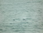
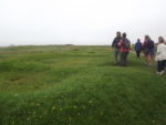
About half way down the peninsula we stopped at another PC site at Port at Choix. This is the site of another archeological dig, but this time it was of the early settlement of the area by the Innu and PaleoEskimo populations who inhabited the area for centuries hunting for fish, whales and seals. The visitor centre laid out the history of the sites, but it took a 2 km hike to get to where the artefacts had been found at the village site. They estimate that the site had been inhabited as much as 4000 years ago! Also in Port aux Choix, we visited the French Cultural Centre to watch a home video from the 60s, of a family with ten children relocate from an outport, eight miles away, to the town. In scenes reminiscent of a Michael Crummey novel, the family and friends managed to get their two storey wooden house into the sea to be towed by fishing boats to its new home – no barge or support platform. It was half submerged during the journey and, reaching its destination, was manhandled up a steep incline to an unserviced lot. This act of desperation was to gain access to education and healthcare and the government awarded them $600 in compensation.
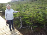
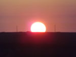
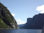
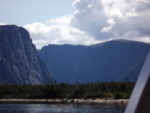
We spent three nights in Gros Morne National Park, probably the best known attraction in Newfoundland. While most of the province is pretty flat, this area has a lot of relief and there are many walks and multi-day hikes one can do as it marks the end of the Appalachian Trail. We were in a campsite that has electric hook-ups for the camper and excellent wifi – not exactly roughing it. We did a couple of shortish hikes and spent a day visiting West Brook Pond which is a freshwater lake about 12 km long akin to a fjord. In fact the deep valley had been created by glaciers exiting to the sea, but once the glaciers melted, the earth rebounded and rose enough that the fjord was cut off from the sea. To get to the lake from the highway was a 3 km walk across what was largely a peat bog, fortunately with boardwalks. At the lake we took a 2 hour boat trip to the top end of the ravine – quite spectacular with good waterfalls after the recent rains. We had a beautiful summers day for this.
Our time on the Rock has been most illuminating on what it means to be a Canadian. Certainly what it means to be a Newfie is to be very tenacious to survive in such a hostile and unforgiving environment. It means being very resilient to withstand the collapse of the cod and salmon fisheries and the downturn in the oil industry. It also means having a great sense of humour and the ability to laugh at oneself.
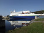
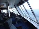
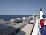
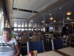
This blog is being finalized as we make the crossing from Port aux Basques NL to North Sydney NS, a 7 hour trip in a large ferry, about half the load being commercial. It is far from full and we have lovely reclining seats with a panoramic view of the flat sea to the rear.
We intend to spend the next week in Nova Scotia.